At the Brandstatt site, various investigation methods have been employed to gain insights into the geological and geomorphological conditions of the subsurface. As reported in the other sites, these include the combination of direct techniques (such as percussion drilling, soil core extraction and analysis, dynamic probing), and installations for monitoring slope hydrology and landslide displacements. In addition, indirect and non-invasive geophysical methods (e.g., Electrical Resistivity Tomography (ERT), electromagnetic induction (EMI), and Spectral Induced Polarization (SIP)) have been conducted in collaboration with the Vienna University of Technology (TU Wien), led by Ass.-Prof. Dr. Adrian Flores-Orozco and his team.
The subsurface investigations conducted as part of this project include 62 soil cores, and ca. 40 Dynamic Probing Heavy (DPH) measurements. These data were collected between April 2022 and September 2024, as part of the project itself and a project-related course in March 2023. Currently, several sensors are installed for the ongoing monitoring (Figure 29):
-
9 TDR probes at three locations, measuring soil water content at 0.5, 1, and 2 meters (at the moment, n. 8/9 are active);
-
3 piezometers measuring water column height between 4 and 6 meters (at the moment, n. 2/3 are active);
-
5 manual inclinometers installed at varying depths across the unstable slope (~4.5 to 5 to ~6 meters from April 2022 to September 2024).
These data are crucial for understanding the dynamics of the slope and implementing future research and mitigation efforts.
All data recorded by the permanent installations are collected every 5 min and are sent directly to the server in Vienna, where these are processed. Moreover, the collected data can be viewed in real-time at the webpage.
 Figure 29: Location of the monitoring devices installed at the Brandstatt landslide observatory. In addition, selected locations where DPH tests have been performed in the area in 2022 and 2023. Orthophoto is provided by the Federal State Government of Lower Austria.
Inclinometer
Subsurface movements within the unstable mass are monitored using manual inclinometers. Due to the technical limitations of the drilling equipment, current investigations are focused on shallower layers, with monitoring reaching depths between 4.5 and 6 meters. Five inclinometers have been installed at the study site, each using grooved plastic casings inserted into boreholes. Data is collected using a measuring probe and manual data logger during fieldwork activities with fieldwork activities carried out approximately once a month. Furthermore, a 40-meter-long chain inclinometer from Measurand was installed during the deep drilling process.
Piezometers and TDR probes
In total, 3 piezometers have been installed in the summer of 2022 to measure underground water pressure in the eastern sector of the unstable slope, with sensor depths ranging between 4 and 6 meters below the surface. Due to technical challenges associated with the distance between the sensors and the acquisition data logger and power system, piezometers could not be installed in the western sector.
In order to obtain additional information about the soil moisture at different depths, a total of 9 TDR probes have been installed at three locations at three different depths respectively (each at 0.5, 1 and 2 meters). Both piezometer and TDR data are recorded every 5 minutes and are transmitted automatically to a server in Vienna, where they can be accessed in near real-time (link).
Dynamic probing (DPH), percussion drilling, soil core extraction and laboratory analyses
In addition to the permanent installations, the subsurface is also explored through dynamic probing heavy (DPH) tests and percussion drilling. Between 2022 and 2023, a total of ca. 40 DPH profiles have been conducted at the site. Their analysis is part of the ongoing investigation.
The drill cores (62) and soil samples have been extracted to characterize the soil stratigraphy in the subsurface. These are analyzed in the laboratory testing and evaluated as part of various final theses. Corresponding results are in progress.
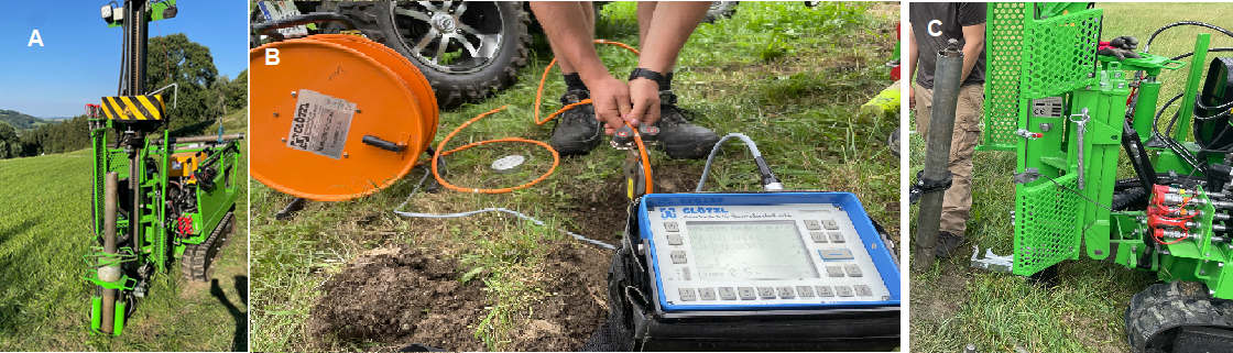
Figure 30: Impressions of fieldwork activities at the Brandstatt site in 2022. A) and C) Percussion drilling and extraction of soil cores; B) Example of inclinometer measures using the measuring probe and the manual data logger. (images courtesy of R. Kanta)
")
")