The Salcher landslide is located in the municipality of Gresten, Scheibbs district, Province of Lower Austria. It is located on an treeless slope orientated from west to east (at around 435 to 470 m above sea level / slope inclination between 5° and max. 20°). The site is enclosed on three sides by anthropogenic features /streets / houses). Like the Hofermühle site, the Salcher landslide is located in a geologically complex transition zone of the Flysch Zone, the Grestener Klippen Zone and the Northern Calcareous Alps (Figure 15). The deeply weathered rocks in this area and their high proportion of clay and its weathering products are among the main reasons for the fact that this area has one of the highest susceptibilities to landslides in (Lower) Austria (see, among others, Gottschling 2006; Petschko et al. 2014).
The processes at the Salcher landslide are to be classified as rotational sliding, whilst more than one sliding surface can be assumed. The currently active area is ~ 4,000 m², the area to be potentially activated is ~ 20,000 m².
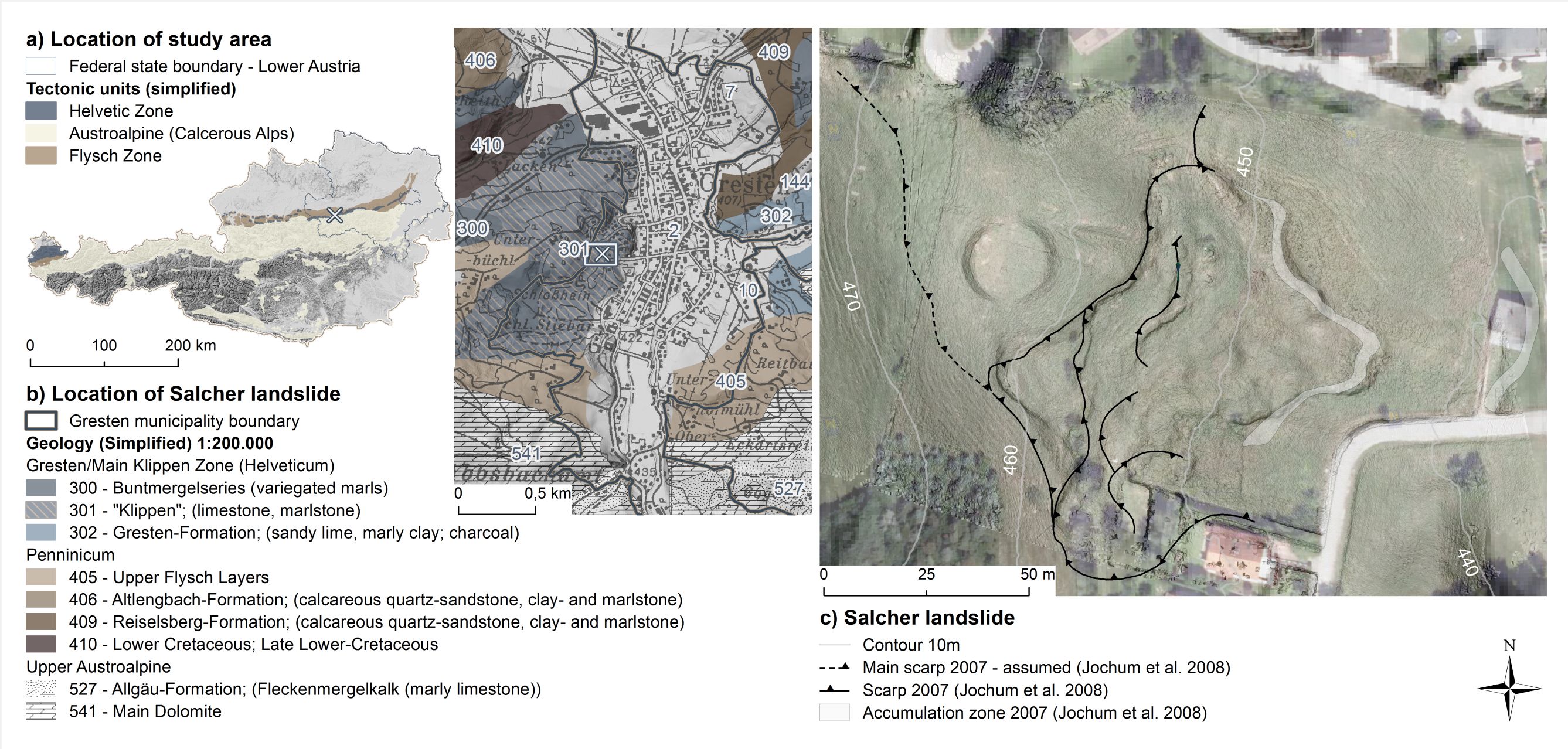
Figure 15: a) Location of the study area in western Lower Austria, Scheibbs district. b) Location of the Salcher landslide, Gresten municipality; geological embedding. c) The Salcher landslide; active process area approx. 4,000m². (Data sets and sources used to create the figure: DEM (1m) 2009 and Orthophoto 2010: provided by the Federal State Government of Lower Austria; geological maps: Schnabel et al. (2002) and Weber (1997); mapping on the Salcher landslide: Jochum et al. (2008)). Graphic from Stumvoll et al. 2019.
Reports of damage caused by landslide activities to the Federal State of Lower Austria since the 1970s (Schwenk 1976, 1979, 1992) led to investigations by the Geological Service of Lower Austria (Schweigl 2007, 2008, 2013) and the Geological Survey of Austria (GBA) in cooperation with the University of Natural Resources and Life Sciences (BOKU) (Jochum et al. 2008).
The corresponding slope was used as a ski slope between the 1950s and 1970s (Figure 14, left). In 1975 landslide activity was reported for the first time as a result of heavy rainfall between June 29 and July 3. The landslide was reactivated by heavy precipitation on May 31, 1978. A prolonged period of intense precipitation between August 1 and 7, 2006 again led to increased landslide activity. Detailed investigations by the Geological Service of Lower Austria were the result. Irregular movement monitoring was discontinued in 2012 after the annual movement rate since 2009 was only in the order of a few centimeters.
After a further reactivation in 2013, the decision was made to use the Salcher landslide as one of the main investigation areas for the NoeSLIDE project and to investigate it intensively over the years. A separate power and broadband internet connection was also set up for this location in order to send all automatically collected data in real time to a data server in Vienna and to make it available here on the homepage in Monitoring.
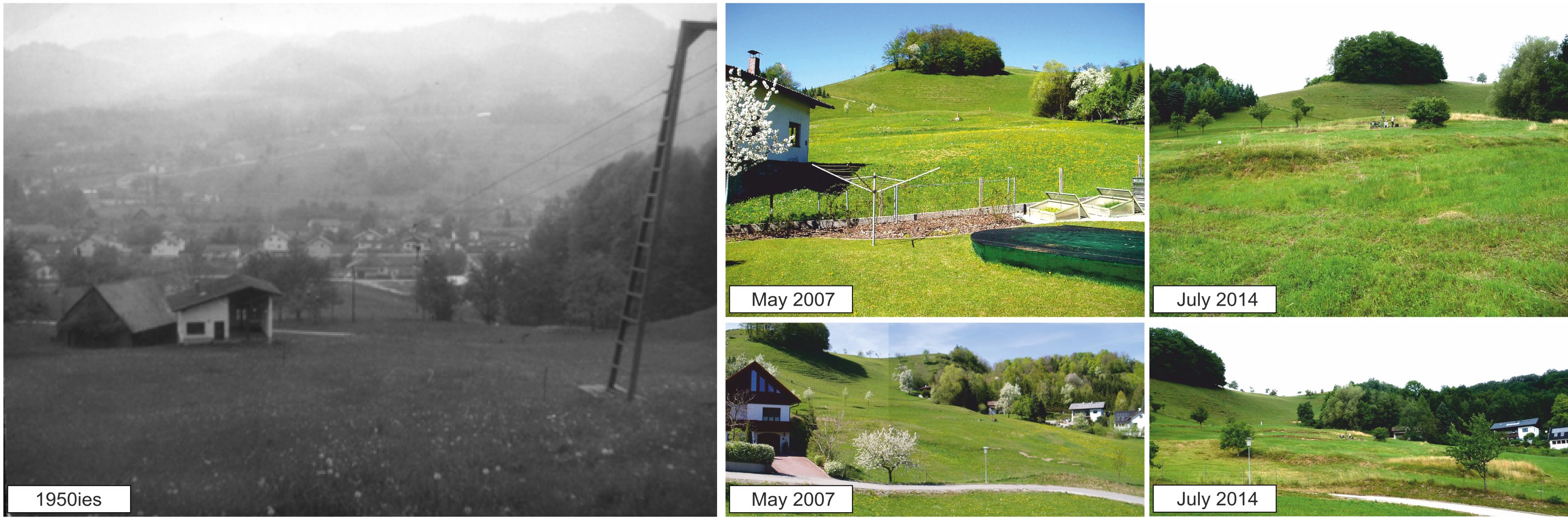
Figure 16: left) Historical view of the Salcher landslide (around 1950s; © photography: Marcel Mollik; right) The surface of the Salcher landslide in 2007 and 2014 (© Photographs: University of Vienna (2007/2014)). Graphic from Stumvoll et al. 2019.
The following pages on subsurface and surface monitoring provide an overview of the monitoring instrumentation used in Gresten and its specifications. A map overview of all installed devices can be found in Figure 16 (status 2018, update under construction).
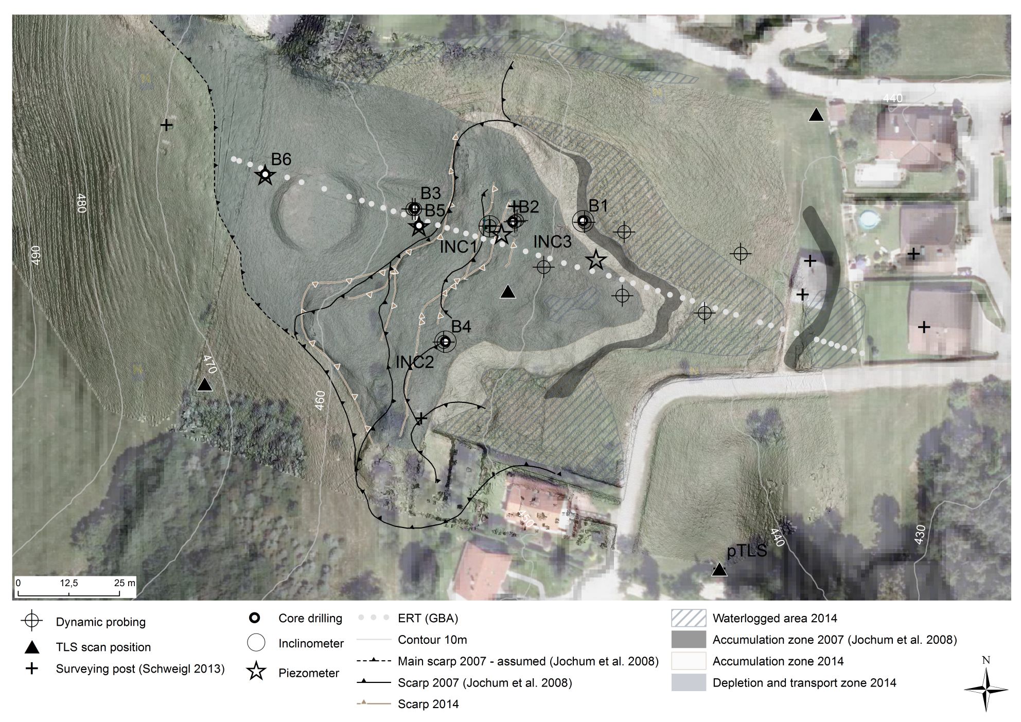
Figure 17: Overview of the monitoring instrumentation at the Salcher landslide (data sets and sources used to create the graph: DEM (1m) 2009 and Orthophoto 2010: provided by the state of Lower Austria; DEM (0.10m) 2014: property of the University of Vienna; geomorphological mapping Jochum et al. (2008). Graphics from Stumvoll et al. 2019.
Literature
The results presented here are taken from a study by Stumvoll et al. 2019, to which a great number of people contributed. A majoritiy ot the graphs presented here are taken as well from this study. Additional references mentioned:
Gottschling, P. 2006. Massenbewegungen. In Geologie der österreichischen Bundesländer - Niederösterreich, eds. G. Wessely, I. Draxler, G. Gangl, P. Gottschling, M. Heinrich, T. Hofmann, W. Lenhardt, A. Matura, R. Pavuza, H. Peresson & R. Sauer, 335-340. Wien: Geologische Bundesanstalt.Jochum, B., M. Lotter, F. Ottner & K. Tiefenbach. 2008. Geophysikalische und ingenieurgeologische Methoden zur Untersuchung von durch Massenbewegungen bedingte Bauschäden in Niederösterreich. BBK-Projekt NC-62/F (2007) und ÜLG-35 (2007). Endbericht zur Fallstudie Gresten (NÖ). 111. Vienna, Austria: Geological Survey of Austria (GBA); University of Natural Resources and Life Sciences (BOKU).Schnabel, W., H.-G. Krenmayr, G. W. Mandl, A. Nowotny, R. Roetzel & S. Scharbert. 2002. Geologische Karte von Niederösterreich 1:200.000. ed. W. Schnabel. Wien, Österreich: Geologische Bundesanstalt.Schweigl, J. 2007. Gemeinde Gresten, Katastrophenschaden bei den Wohhäusern der Familien Bramreiter und Plank am Pichelkogel. Katastrophenerhebungsblatt. Geologisches Gutachten. (BD1-G-142/001-2007) (intern). 5. Geological office of the Federal State Government of Lower Austria.Schweigl, J. 2008. Gresten, Katastrophenschaden Krause (Gst.Nr.1999/1), Bramreiter (Gst.Nr.1999/6) u.Plank (Gst.Nr.1999/7) am Pichelkogel/Osthang, geotechnische Stellungnahme zur wissenschaftlichen Studie der GBA und Boku. (BD1-G-142/001-2007) (intern). 2. Geological office of the Federal State Government of Lower AustriaSchweigl, J. 2013. Gresten, Krause (Gst.Nr.1999/1), Bramreiter (Gst.Nr.1999/6) u.Plank (Gst.Nr.1999/7) Katastrophenschaden 2006, Rutschung Salcher, geologischer Abschlussbericht zu den Vermessungen. (BD1-G-142/001-2007) (intern). 4. Geological office of the Federal State Government of Lower Austria.Schwenk, H. 1976. Erhebungsbericht und Gutachten des geologischen Dienstes der Baudirektion. (No. BD-3120/1-1975) (intern). 4. Geological office of the Federal State Government of Lower Austria.Schwenk, H. 1979. Erhebungsbericht und Gutachten des geologischen Dienstes der Baudirektion. (No. BD-G-78156) (intern). 3. Geological office of the Federal State Government of Lower Austria.Stumvoll, M. J., E. Canli, A. Engels, B. Thiebes, B. Groiss, T. Glade, J. Schweigl & M. Bertagnoli, 2019. The “Salcher” landslide observatory—experimental long-term monitoring in the Flysch Zone of Lower Austria. Bulletin of Engineering Geology and the Environment, 18. 10.1007/s10064-019-01632-wPetschko, H. et al., 2014. Assessing the quality of landslide susceptibility maps – case study Lower Austria. Natural Hazards and Earth System Science, 14(1), pp.95–118.Weber, L. 1997. Flächendeckende Beschreibung der Geologie von Österreich 1:500.000 im Vektorformat. Exzerpt (Basiskarte Geologie) aus der Metallogenetischen Karte von Österreich 1:500.000. Wien, Österreich: Geologische Bundesanstalt.
Additional literature with respect to the site:
Engels, A. 2015. Landslide dynamics -From historical data to monitoring systems: an approach in Gresten, Lower Austria (Masterthesis; unpublished). 173. Vienna, Austria: University of Vienna.Canli, E., A. Engels, T. Glade & M. Bertagnoli. 2016. Surface and subsurface monitoring of an active landslide in Gresten (Austria). In 13 th INTERPRAEVENT Conference, 30 May to 2 June 2016, Lucerne, Switzerland, Extended Abstracts, ed. G. Koboltschnig, 72-73. Lucerne, Switzerland.Gallistl, J., M. Weigand, M. Stumvoll, D. Ottowitz, T. Glade & A. F. Orozco (2018) Delineation of subsurface variability in clay-rich landslides through spectral induced polarization imaging and electromagnetic methods. Engineering Geology, 245, 292-308. https://doi.org/10.1016/j.enggeo.2018.09.001Stumvoll, M. J. & T. Glade, 2017. NoeSLIDE - Monitoring unterschiedlicher Typen gravitativer Massenbewegungen in Niederösterreich.- Interner Abschlußbericht für den Geologischen Dienst, Land Niederösterreich. 37. Wien: Universität Wien, Institut für Geographie und Regionalforschung.
")
")